inpPINS 0.1 beta

Free inp.PINS generates SWMM input file (.inp) based on GIS files
4 
Rating
Your vote:
Latest version:
0.0 See all
Developer:
Screenshots
1 / 1
Awards (1)
Show all awards
Software Informer Virus Free award
Download
Free  

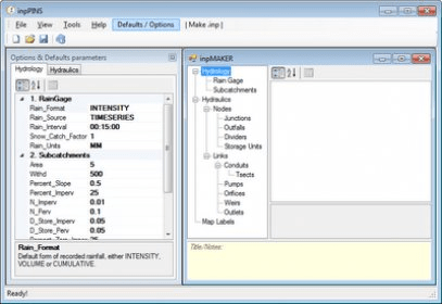
inpPINS is designed to integrate Storm Water Management Model (SWMM) with Geographic Information Systems (GIS). The main idea is to link SWMM visual objects between these two platforms and not include numerical data that is not necessary to define these objects.

Comments (2)

User

Your vote:

S
sunchangfeng
How can I download it?

Was it helpful?  yes(3) no(0) | Reply
N
Nordine Bjerke
Dear sunchangfeng,
Kindly follow the direct link to download the software: http://inppins.software.informer.com/download/?cf14f838

Was it helpful?  yes(6) no(4) | Reply

Related software

Arduino
Arduino
Free
rating

Program all variants of Arduino kits with ATmega microcontrollers.

PINs
PINs
Free
rating

Windows program for safe storing of any secure information.

Argus ONE
Argus ONE
rating

Enable to easily prepare your data for any modeling package.

GiS BasePac
GiS BasePac
rating

BasePac 8 is a modular application for the embroidery industry.

InteGNPS
InteGNPS
rating

A software used for NC(Numerical Control) cutting machine nesting & programming

Related suggestions